Updates in Google Maps and Search help in times of crisis
Google introduced SOS alerts in 2017, to help members of the public to access authoritative, real-time information rapidly during times of crisis. Now, the company says it has recently improved the service by adding visual information about natural hazards or human-caused crises. It has also added a new navigation warning system on Google Maps so the location of an event can be known and if necessary, the direction in which it is heading.
In addition to being able to see crisis information using SOS alerts, (including a summary of what’s happening, relevant news stories, emergency phone numbers and websites, Twitter updates from local authorities, and advice on how to reach safety), it is now possible to see detailed visualisations about hurricanes, earthquakes, and floods to provide a better understanding of the situation on the ground.
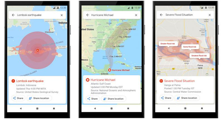
The updates provide much more detailed information about hurricanes, earthquakes and floods. All images: Google
In the days leading up to a hurricane, a crisis notification card on Google Maps will automatically appear if the user is close to the affected area. This card will direct them to a hurricane forecast cone, which shows the prediction of the storm’s trajectory, along with information about what time it’s likely to hit certain areas, so the information can be used to plan how to react.
After an earthquake strikes, a tap on the crisis card will display the earthquake’s shakemap – a visualisation that displays its epicentre and its magnitude, along with colour coding to indicate the intensity of tremors in surrounding areas. This information can help to assess the reach of the earthquake and identify areas likely to have experienced the highest impact. In India, where over 20 per cent of global flood-related fatalities occur, it will now be possible to see flood forecasts that show where flooding is likely to happen, in addition to the expected severity in different areas.
Later this summer, the introduction of a prominent alert will be established to notify the user if their route becomes affected by crisis activity and, where possible, a diversion will be provided to help avoid the incident.
Google has also suggested some other ways to use Google Maps to stay connected and obtain the relevant help and information required. These include:
Share location – from the crisis card, it is possible to share live location with friends and family for as little as 15 minutes
See and report road closures – the traffic layer can be used to see all known and suspected road closures in an area. Using Google Maps, these can be confirmed or reported to help others nearby
Share crisis information directly with contacts – the crisis card has a share button that can be used to update family and friends about the situation by diverting them to Google Maps
Hurricane forecast cones and earthquake shakemaps will start rolling out this summer on Android, iOS, desktop, and mobile web. Flood forecasts visualisations will soon roll out, starting in Patna, India, and then expanding to the Ganges and Brahmaputra regions on Android, desktop, and mobile web.
For more information, read here